
Digital Compass Altimeter Handheld Hiking Thermometer 8 in 1
3.4Editor score
Eight functions in one device
Backlight for night reading
Compass and barometer included
Finding the right handheld altimeter is essential for outdoor enthusiasts who need reliable elevation data. Whether you are hiking mountain trails or navigating remote terrain, a precise instrument helps ensure safety and successful navigation during your adventures.
We have carefully evaluated ten leading models based on accuracy, durability, and ease of use. Our analysis includes both analog and digital options to provide a comprehensive overview of what is available for serious adventurers and casual hikers alike.
Each pick below highlights specific strengths and ideal use cases for different types of users. Please note that product availability and pricing can change over time, so verify current details before making your final purchase decision.
3.4Editor score

4.6Editor score
4.3Editor score
As an Amazon Associate we earn from qualifying purchases.
The following table provides a side-by-side comparison of all ten products we reviewed to help you quickly identify which model meets your specific outdoor navigation needs.


The Garmin GPSMAP 65s stands out as the top choice for serious outdoor navigation due to its advanced multi-band technology and reliable barometric altimeter. With a 4.6 rating, users appreciate its ability to maintain accuracy even in challenging terrain like urban canyons or dense forests. This device is built for those who need comprehensive mapping capabilities alongside precise elevation data.
We may earn a commission when you buy through this link, at no additional cost to you.
Its standout feature is the expanded satellite support which ensures you stay connected in areas where standard GPS might struggle. The 2.6 inch color display makes viewing maps and elevation trends easy even under bright sunlight. Additionally, the inclusion of routable TopoActive mapping provides essential context for planning your route and tracking progress effectively.
While the device offers top-tier performance, it does come with a higher price point compared to simpler analog options. You will also need a compatible smartphone if you wish to utilize the full potential of the Garmin Explore website and app for detailed statistics review. These trade-offs are acceptable for users who prioritize precision and mapping features over budget constraints.
This handheld altimeter is ideal for hikers, mountaineers, and outdoor professionals who require dependable navigation tools. If you value accuracy and detailed mapping above all else, the GPSMAP 65s delivers a professional-grade experience that justifies the investment for serious adventures.
Multi-band technology ensures optimal accuracy in challenging locations such as steep country or dense tree cover.
Routable TopoActive mapping allows for detailed route planning and navigation without relying solely on digital signals.
We may earn a commission when you buy through this link, at no additional cost to you.
The Digital Compass Altimeter Handheld Hiking Thermometer 8 in 1 offers a budget-friendly entry point for hikers needing basic elevation tracking. With a 3.4 rating, it serves well for casual outings where cost is a primary concern. This device combines multiple tools into one compact unit to save space in your gear while providing essential data for navigation.
We may earn a commission when you buy through this link, at no additional cost to you.
Its key strength lies in its versatility as an 8-in-1 instrument that measures altitude, barometric pressure, temperature, and direction. The electronic backlight ensures you can read data in low-light conditions without needing extra equipment. For those who do not require professional-grade precision, this multi-functional tool provides sufficient information to track changes during mountain climbing or hiking.
However, the lower rating reflects some limitations in accuracy and build quality compared to more expensive options. Users may find the plastic housing less rugged than alloy alternatives and the readings may vary slightly in extreme conditions. Despite these trade-offs, it remains a practical choice for weekend warriors who want functionality without a significant financial commitment.
This model is best suited for budget-conscious hikers or beginners exploring outdoor activities. If you need a simple tool to check elevation and direction without spending much, this 8-in-1 device offers a convenient and accessible solution for your next trail adventure.
This device integrates an altimeter, barometer, compass, and thermometer to provide a comprehensive outdoor tool set.
The simple interface and affordable price make it an ideal first handheld altimeter for new outdoor enthusiasts.
We may earn a commission when you buy through this link, at no additional cost to you.
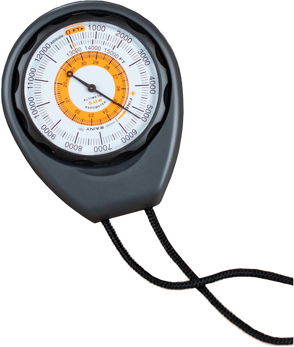
The Sun Company Altimeter 203 earns its spot as a premium analog option due to its rugged design and reliable battery-free operation. With a 4.3 rating, it appeals to hikers who prefer mechanical tools that do not depend on batteries. This device is crafted to withstand harsh conditions while providing clear altitude readings up to 15000 feet.
We may earn a commission when you buy through this link, at no additional cost to you.
Its standout feature is the weather-trend indicator which helps predict incoming high or low-pressure systems. The adjustable dial allows you to calibrate for current pressure conditions ensuring accurate readings on your hike. Combined with a durable ABS case and included lanyard, it offers excellent portability and protection for outdoor use.
The main trade-off is the need for manual calibration since it does not auto-adjust like digital models. Additionally the altitude range is limited to 15000 feet which may not suit high-altitude mountaineering. However for general hiking and camping these limitations are often acceptable given the reliability and ease of use.
This analog altimeter is perfect for purists who value simplicity and durability over electronic features. If you need a dependable tool that works without batteries and provides weather insights, the Altimeter 203 is a robust choice for your outdoor kit.
The built-in weather trend indicator helps you anticipate changes in air pressure before they impact your trip.
Relying on barometric pressure mechanics ensures the device works indefinitely without needing replacement batteries.
We may earn a commission when you buy through this link, at no additional cost to you.
The BTMETER BT-100WM is a unique handheld device that combines altitude tracking with wind speed and humidity measurement for comprehensive weather data. With a 4.1 rating, it serves well for activities like sailing or drone driving where wind metrics are as important as elevation. This digital meter offers high precision readings for multiple environmental factors.
We may earn a commission when you buy through this link, at no additional cost to you.
Its key strength is the ability to log barometric pressure data which allows for detailed analysis of weather patterns over time. The tripod hole makes it easy to set up for stationary monitoring during long-range shooting or field work. Users also appreciate the ability to switch between various units like mph, km/h, or knots for global use.
The main drawback is that it is not a dedicated hiking altimeter since the design focuses on wind and pressure metrics. You will need batteries to operate it and the display may be less readable while moving compared to compact devices. Still for specialized outdoor tasks it provides a high level of detail and accuracy.
This model is best for enthusiasts who need to monitor wind and temperature alongside altitude. If you are into kite flying or sailing and want a device that captures multiple environmental variables, the BT-100WM delivers versatile performance for those specific applications.
Measures wind speed, temperature, humidity, and pressure to give a complete picture of outdoor conditions.
Built-in data logging allows you to compare and analyze trends across different weather conditions effectively.
We may earn a commission when you buy through this link, at no additional cost to you.
The Digital Altimeter 8 in 1 provides a broad range of features including altitude, compass, and temperature tracking in one handheld unit. With a 3.9 rating, it offers a good balance of functionality and cost for hikers who want more than just elevation data. This model is designed to support various outdoor sports like climbing and camping.
We may earn a commission when you buy through this link, at no additional cost to you.
Its key strength is the impressive altitude range that extends up to 29500 feet allowing use in high mountain environments. The 8-direction display helps keep you oriented even when GPS is unavailable and the barometer tracks air pressure changes due to terrain. A backlight feature ensures the screen remains readable during night operations or in dark caves.
While it covers many functions, the interface can be tricky to navigate for first-time users. Reliance on batteries means you must carry spares for long trips which adds to the overall gear weight. However the versatility of having a thermometer and compass built in makes it a convenient single-tool solution.
This device is well suited for hikers who want an all-in-one digital instrument without buying separate gadgets. If you need reliable elevation data combined with directional and temperature info, this multifunctional tool offers a practical package for your outdoor expeditions.
With a range up to 29500 feet this altimeter supports high-altitude activities like mountaineering.
The electronic compass provides eight directional settings to help you stay on course without a phone.
We may earn a commission when you buy through this link, at no additional cost to you.
The Sun Company AltiLINQ is a specialized analog altimeter designed to monitor elevation changes while driving or on a trail. With a 4.2 rating, it stands out for its battery-free mechanism and easy-to-read scale that fits well in vehicle dashboards. This model appeals to drivers who want to track altitude during mountain road trips.
We may earn a commission when you buy through this link, at no additional cost to you.
Its standout feature is the flexible mounting system allowing it to attach to either the top or front of a dashboard. The adjustable dial ensures accurate readings by accounting for local pressure systems which is helpful for tracking weather trends. When you finish driving, the device can be quickly detached and carried into the wild.
A limitation is its focus on vehicle use which might not appeal to backpackers needing a pocket-sized tool. Since it lacks battery backup, readings depend entirely on environmental pressure which is reliable but requires manual calibration. For the right user, this portability and simplicity make it a unique option.
This altimeter is perfect for truck drivers or campers who monitor elevation during transit. If you want a device that transitions seamlessly from dashboard to backpack, the AltiLINQ offers a simple analog solution for tracking altitude and weather trends.
Hook-and-loop attachments let you secure the device to various dashboard surfaces for optimal viewing.
Mechanical operation ensures the device works without batteries or electronic components for long-term use.
We may earn a commission when you buy through this link, at no additional cost to you.
The Handheld Clinometer Forestry serves as a specialized altimeter and slope tool for users measuring tree heights or terrain angles. With a 4.5 rating, it is highly regarded for its rugged aluminum build and waterproof construction. This device is ideal for foresters, hikers, and field workers who need precise incline data.
We may earn a commission when you buy through this link, at no additional cost to you.
Its key strength is the sighting mechanism which uses a deflection angle lens to quickly determine slope and height. The compact palm size makes it easy to hold steady for accurate readings in the field. Additionally, it is shockproof and durable enough to withstand rough outdoor conditions without damage.
While excellent for angles, it is not a general-purpose altimeter for tracking elevation gains. Users may need to calculate height manually based on the slope readings and distance. However for tasks like measuring buildings or trees, it outperforms standard digital altimeters in reliability and accuracy.
This tool is best for professionals or hobbyists needing to measure angles and inclines. If you work in forestry or architecture and need a rugged sighting tool, the Handheld Clinometer Forestry offers durable and precise performance for your field work.
The deflection angle lens allows for quick and straightforward measurement of slopes and heights.
Constructed from aluminum alloy with waterproof and shockproof properties for long-lasting field use.
We may earn a commission when you buy through this link, at no additional cost to you.
The Carabiner Altimeter Barometer Thermometer stands out for its convenience and portability with a perfect 5.0 rating from users. This compact device integrates an altimeter, barometer, and thermometer into one unit designed to clip directly to your backpack. Its smart weather forecasting provides useful planning for upcoming conditions over the next 12 to 24 hours.
We may earn a commission when you buy through this link, at no additional cost to you.
Its key strength is the integrated carabiner hook which allows for hands-free carrying on belts or tactical vests. The rugged ABS construction ensures it can withstand drops and impacts during hiking or mountain climbing. Users appreciate the simplicity of having essential weather and elevation data accessible without digging into a pack.
A trade-off is the small display which can be difficult to read in bright sunlight or for those with vision issues. It lacks advanced features like GPS or mapping but excels as a quick reference tool for basic metrics. For many, the convenience outweighs these minor limitations.
This model is ideal for hikers who want a simple tool to track temperature and elevation. If you need a reliable and portable gauge that clips on your pack, this 3-in-1 device offers excellent utility and weather insights for your trips.
The integrated carabiner allows you to attach the device to straps for easy and safe carrying.
Built-in barometric sensor predicts weather trends to help you plan your fishing or camping trips safely.
We may earn a commission when you buy through this link, at no additional cost to you.
The Pocket Altimeter Clinometer is a compact tool designed for measuring height and slope with a professional aluminum build. With a 3.9 rating, it serves architects, travelers, and explorers who need a lightweight device for specific measurements. Its battery-free analog operation ensures it works reliably without needing power.
We may earn a commission when you buy through this link, at no additional cost to you.
Its key strength is the high-definition azimuth plate and clear dial which enable quick and clear readings. The compact size makes it easy to store in a pocket or carrying case included with the unit. Users appreciate the sturdy structure and hand strap which prevent loss during exploration.
The main limitation is the need for manual calibration to ensure accuracy during measurements. It is designed more for inclinometer work than general altitude tracking which may limit broader hiking utility. Still, for its specific purpose, it offers a reliable and accurate solution.
This device is best for professionals who need to measure heights or inclines regularly. If you want a portable and durable tool for fieldwork or travel, this pocket-sized clinometer provides the accuracy and convenience you need.
The high-definition azimuth plate and clear dial allow you to read measurement results quickly and accurately.
Made of aluminum alloy to resist compression and shock ensuring longevity in various environments.
We may earn a commission when you buy through this link, at no additional cost to you.
The Altimeter GPS Digital SUNROAD combines GPS navigation with elevation tracking and weather forecasting in one waterproof device. With a 3.2 rating, it offers a range of features including GPS+GLONASS+BeiDou compatibility for accurate positioning. This model is designed for sports enthusiasts who want digital tracking capabilities.
We may earn a commission when you buy through this link, at no additional cost to you.
Its key strength is the multi-functional GPS positioning which tracks speed, distance, and historical elevation trends. The rechargeable battery can be charged via USB which reduces waste from disposable batteries. Users also benefit from the backlight mode and built-in LED flashlight for low-light outdoor conditions.
A drawback is the lower reliability rating which may suggest inconsistencies in sensor accuracy or build quality. The interface includes many functions which can make setup complicated for some users. Despite this, the versatility of having GPS and weather features in one device is appealing.
This model is suitable for users who want GPS tracking alongside elevation data. If you need a device that records routes and predicts weather, the SUNROAD altimeter offers a feature-rich option for outdoor sports and hiking activities.
Compatibility with three satellite systems ensures accurate positioning even in remote or challenging areas.
The built-in rechargeable battery and USB charging cable make it convenient for extended outdoor use.
We may earn a commission when you buy through this link, at no additional cost to you.
Selecting the right altimeter requires considering accuracy, features, and durability to ensure it meets your outdoor needs.
Accuracy is paramount when choosing a handheld altimeter because small errors can lead to navigation mistakes in rugged terrain. Digital models often offer finer resolution and auto-calibration, while analog devices depend on manual tuning to local pressure conditions. Look for models with a reputation for stable readings in changing weather to trust your elevation data.
Prioritize devices with high-precision sensors if you are in high-altitude regions where pressure changes rapidly.
Battery life affects how long you can rely on your altimeter during extended trips. Analog models work indefinitely without batteries, making them ideal for situations where replacing cells is impossible. Digital devices provide extra features but require spare power sources or rechargeable options to remain functional.
Choose analog for long expeditions and digital if you need advanced data tracking features.
Outdoor devices face rough conditions so durability is key to longevity. Look for waterproof, shockproof, and rugged housing like aluminum or ABS plastic that resists drops and moisture. A quality build ensures the device survives impacts and harsh weather while maintaining accurate performance.
Select models with sturdy construction to protect internal sensors from damage during adventures.
A clear display is essential for reading data quickly while hiking or climbing. Digital screens with backlighting are easier to see in low light but may drain power. Analog dials offer simplicity and readability without relying on electricity but may lack resolution for precise tracking.
Choose displays that match your lighting conditions and battery expectations for optimal usability.
Many altimeters offer extra functions like barometers, thermometers, and GPS tracking to enhance utility. Decide which features matter most to avoid paying for unnecessary tools or missing critical data. A multifunctional device can save space but ensure each function performs well independently.
Focus on essential functions that align with your outdoor activities to maintain efficiency.
Calibration determines how easy it is to set your device to local conditions for accurate readings. Analog models need manual adjustment based on current pressure while some digital ones auto-adjust. Consider your ability to calibrate in the field when choosing between mechanical and electronic designs.
Select devices with simple calibration processes to maintain accuracy without complex steps.
Size and weight impact how convenient your altimeter is to carry during physical activity. Compact models fit in pockets or attach to backpacks without adding bulk to your gear. Ensure the device is easy to access and use while keeping your hands free for other tasks.
Opt for lightweight and small designs to reduce strain and improve ease of use.
Cost varies significantly between basic analog devices and advanced digital units with GPS. Determine your budget and balance it against the features you truly need for your trips. Higher prices often mean better sensors and durability but may include functions you never use.
Invest in a model that offers the best value for your specific hiking requirements.
To ensure accurate readings, calibrate your altimeter before starting your hike using a known elevation point like a trailhead marker or a GPS device.
Keep the device away from electronic interference and extreme heat which can affect sensor performance and internal components over time.
Regularly clean the exterior with a soft cloth and store in a dry place to prevent moisture damage and maintain the display's readability.
Handheld altimeters use barometric pressure which can be more accurate locally than GPS elevation data. GPS relies on satellite triangulation which can fluctuate while pressure sensors track altitude based on air density changes. For consistent results, calibrate your device to known elevation points before use.
Yes, analog altimeters work well in extreme cold since they do not rely on batteries that freeze. However, ensure the housing is insulated or made of metal to withstand thermal contraction. Always calibrate before use to account for temperature effects on pressure readings.
Yes, digital models require batteries or recharging to operate. Some have auto-shutoff features to conserve power during long periods of inactivity. Keep spare batteries handy for trips lasting longer than your device's battery life to avoid downtime.
A barometric altimeter measures altitude by detecting changes in atmospheric pressure. As you ascend, air pressure drops and the device calculates elevation based on this difference. It is often more responsive to small changes than GPS for hiking purposes.
Yes, some models like the AltiLINQ are designed with mounts for vehicle dashboards. They track altitude changes during mountain driving to provide real-time elevation data. This helps monitor pressure shifts without relying on navigation apps.
Pressure changes due to weather systems can affect altimeter readings even if your location stays the same. Re-calibrating the device to a known elevation point corrects this drift. Regular calibration ensures consistent and reliable results for your trips.
We have reviewed ten excellent options ranging from rugged analog models to feature-rich digital devices. The Garmin GPSMAP 65s stands out for advanced navigation while the Sun Company Altimeter 203 offers reliable analog simplicity for hikers.
Prioritize accuracy, durability, and battery life based on your specific needs. Whether you want a compact tool or a multifunctional device, matching features to your activity type ensures you get the most value from your purchase.
Remember to check current availability and pricing as these details can change frequently. By selecting the right handheld altimeter, you gain confidence and precision for all your outdoor adventures.